Dublin Area District Electoral Division Census Data, 1901
District Electoral Divisions, subdivisions of Poor Law Unions, were the basic building block for electoral constituencies. In many respects they are similar to Census Tracts of the United States Census. US census tracts, overall, have much more people than did Irish DEDs. For example, in the 2000 US Census the state of Alabama had a population of 4,447,100 and 1181 census tracts (3,766 persons per tract). In the 1901 census Ireland had a population of 4,458,775 and 3,636 DEDs (1,226 persons per DED, one-third the Alabama average).
District Electoral Divisions, 1901
Dublin and Environs with Railways

Sources: Ordnance Survey, Boundaries of Administrative Areas (including district electoral divisions), Census of 1911, prepared for the Department of Local Government and Public Health; Thom's Map of the City of Dublin and its Environs (city wards colored), c. 1904; The Ordnance Survey of Ireland, 1907-08 Revision; Supplement to the General Topographical Index of Ireland, Census of Ireland, 1911; Census of Ireland, 1901.
Download Files of the Above Map
ESRI Shapefiles (DublinAreaDEDShapefiles.zip)
The vector layers (CountyDublin, DublinAreaCityPolygons, DublinDEDsWithData, DublinRailaways, Sea) are compressed in the zip file (181kb). DublinDEDsWithData is the district electoral division polygon vector file. CountyDublin is the county polygon file from the Ordnance Survey Ireland, edited. Included are text files that describe the census data (File Description.txt) and give the map sources (sources.txt). If you download this zip file there is no need to download a data file as all the data is in the attribute file, DublinDEDsWithData.dbf, readable by Excel.
Download Data Files, Census of 1901
Name of district electoral division, total population, area in acres and square kilometers, xcentroid, ycentroid, city name, population per square kilometer, number of houses - occupied, vacant, building, property value, one-room tenements - total and number occupied by 2, 3, 4 ... 12 persons, urban district flag, number of males and females age 21 to 39 and >=40, illiteracy rate for persons age 5 and older, religious professions - Catholic, Anglican, Presbyterian, Methodist, Other, number of primary schools - boys, girls, mixed, number of superior schools - boys, girls, mixed. Schools excludes workhouse, industrial, orphanage, and regimental schools. Schools includes state, church, and proprietary establishments.
Data File, Excel (DublinAreaDEDGeoData.xlsx)
30kb Excel file.
Data File, Tab-Delimited Text (DublinAreaDEDGeoData.txt)
16kb ASCII text file.
Population Density
Property Value

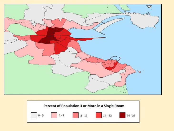
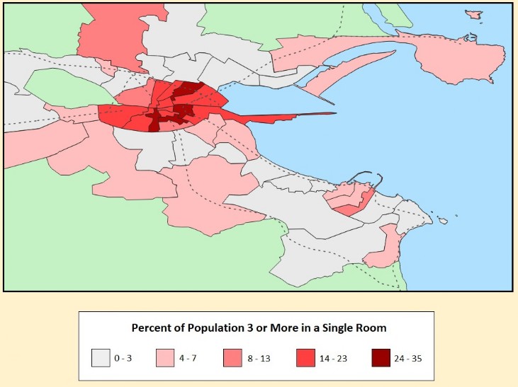
Overcrowding
[ You are at www.majortweedy.com>Dublin>District Electoral Divisions ]