Interactive Dublin Map, c. 1904
Multi-layer map on this website with a standard "Leaflet" webmap interface. Use the browser "back button" to return to this page from the map. See below for user instructions and layout.
Click on the above link and allow some time for the map to load; it has layers of large image files. (It will take about twenty seconds with 35 Mbps service.) You may receive a message that a script is slowing down the webpage - ignore it. You may also access the map by clicking on the image below.
The map will open in this browser window. To access the map directly from a browser go to the URL
dubmap-4.majortweedy.com
Instructions
Below is a screenshot of the map upon opening. The map is centered on Nelson's Pillar.
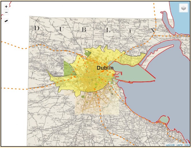
In the upper-left are the zoom buttons, . + . to zoom in, . - . to zoom out. Note that the base files are very large, uncompressed image files. Accordingly, as you zoom it will take some time for the maps to redraw and appear clearly. You can also use the mouse scroll wheel to zoom.
Below the zoom icons is the ruler icon.  Place the cursor on it then click on "Create a new measurement." In keeping with 1904, the ruler is set to Imperial Measures. Note that when you create the first measurement point, map coordinates (decimal and minutes form) are displayed.
In the upper-right is the layers menu icon.  Click on it and the layers map legend will open. Click in the boxes to make a layer visible/invisible.
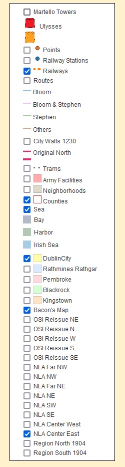
The map has point, line, and polygon (area) layers. All but the Sea layer are transparent. Note that you cannot adjust a layer's transparency level.
To move the map in the browser window, hold down the left mouse button and "drag" the map.
Map Layers
Base Maps
Bacon's Plan of Dublin and Suburbs, c. 1905, 6" to the mile. Dublin, Rathmines & Rathgar, and most of Pembroke. Digitized by the New York Public Library.
Dublin Suburbs - Ordnance Survey Ireland's 1931 partial revision of the British 6" maps, 3rd Edition. Most of the revisions are simply place name changes made by the Irish Free State. The maps were reduced to a scale of about 3.3" to the mile (OSI Reissue).
Dublin County and Surrounding Area: Ordnance Survey of Ireland 1" to the mile maps digitized by the National Library of Australia (NLA).
Dublin Region - Ordnance Survey of Ireland 1904, ¼" to the mile maps digitized by the David Rumsey Map Collection, Stanford University Libraries.
Polygon Layers
Army Facilities: War Office properties in Dublin and surrounding areas. Note the fort at the tip of Kingstown's East Pier and the Government Horse Farm in Lusk, about 13 miles northeast of Nelson's Pillar.
Sea: Irish Sea, Bays, and Harbors at high tide.
Neighborhoods: As these are not "official" areas, the boundaries are merely a guide. Colored transparent gray and labeled.
City Polygons: City limits on Bloomsday. Each municipality has its own transparent polygon.
Line Layers
Railways: Railway lines represented by thick, dashed orange lines.
City Walls 1230: Old city walls, c. 1230. The earlier north walls are represented by thinner lines.
Routes: Movements of several characters on Bloomsday.
Trams: All tram lines in 1904 that originated in Dublin, including the steam tramway to the Spa Hotel in Lucan. Shown with, dashed black lines. Line numbers shown in the popups are for informational purposes as tramway lines weren't numbered until the 1930s.
Point Layers
If at a given zoom level points cannot be displayed distinctly, they will be represented by a cluster icon, examples follow:

As you zoom in, the cluster icons dissolve and the individual points appear.
Martello Towers: Labeled icons that mark towers extant in 1904. The two mentioned in Ulysses are colored red.
Points: Various places mentioned in or related to the novel.
Railway Stations:
Feature Information
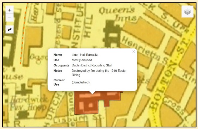
As you hover the "grabber" cursor over map features, it will change into a "pointer" cursor  . If you then left-click the mouse a small window with information on that feature will popup. Popup information is available only for drawn features and not the base maps.
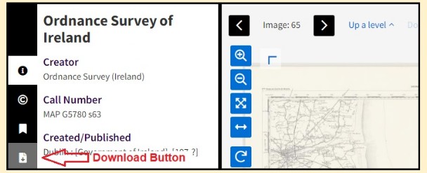
Downloads
Bacon's map is available from the digital collections website of the New York Public Library. The 1" maps are available from the website of the National Library of Australia. The ¼" maps can be found on the website of The David Rumsay Map Collection. The drawn layers are ESRI shapefiles and can be downloaded from Major Tweedy's Neighborhood.
The map page will open in a new browser window. You can choose among 6 different resolutions. The smallest is in a 40kb file while the largest, a .tif file, is 55 MB and will take a long time to download. Click on the icon to the right for the home page of NYPL Digital Collection.

1-Inch Maps at the National Library of Australia
Click on the links below and the map page will open in a new browser window. For the home page of the National Library of Australia, click on the icon to the right. It too will open in a new browser window.

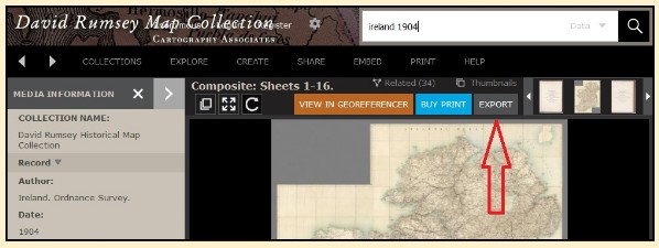
¼-Inch Maps at the David Rumsey Map Collection.
Click on the links below and the map page will open in a new browser window. For the collection's home page, click on the icon to the right. It too will open in a new browser window. To download an individual map from the viewer click on the "Export" tab.

The shapefiles, Coordinate Reference System WGS 84, are compressed into Dublin1904Shapefiles.Zip (11.8 MB). The file resides on this website.