Garrison Library's Ordnance Survey Maps
The Garrison Library of Gibraltar has digitized a number of early 20th century Ordnance Survey maps of the colony. Unfortunately, the index map sheet is too small and somewhat confusing. You may find it easier to use this page to access those maps. Note that the scanned images are medium resolution.
Click on the number on the map or number in the table and the OS Map on the Garrison Library website will open in a new browser window.
No. | Description | Year |
Sundial Roundabout | 1941 | |
Buffadero Training Area | 1941 | |
Devils Tower Road | 1941 | |
New Jewish Cemetery | 1948 | |
HM Naval Base Plans | 1902 | |
Upper Rock | 1932 | |
The Mount | 1932 | |
HM Naval Base | 1929 | |
Laguna Estate | 1940 | |
Water Catchment | 1930 | |
Bristol Hotel | 1951 | |
Moorish Castle | ||
Buffadero Battery | 1942 | |
Coaling Island | 1942 | |
Gibraltar Entrance | 1944 | |
Border - Eastern Beach | 1944 | |
Europa Point | 1942 | |
Little Bay | 1944 | |
Sandy Bay | 1934 | |
Dockyard South Mole | ||
Rock Hotel | ||
Grand Parade | 1945 | |
Wellington Front | 1931 | |
Rosia Bay | 1908 | |
Rock Gun Battery | 1941 | |
Spyglass | 1931 | |
Dry Docks at New Mole | 1905 | |
Alameda Gardens | ||
Gun Wharf, Naval Base | ||
Signal Hill | 1941 | |
Catalan Bay | 1931 | |
Spur Battery | 1906 | |
Naval Hospital | 1932 | |
Windmill Hill Barracks | 1941 | |
Mediterranean Steps | 1941 | |
Loretto Convent | 1932 | |
Cloister Ramp | 1948 | |
Casemate Square | 1941 | |
Strait Admiralty Chart | 1831 | |
HMNB to Sandy Bay | ||
Same area as 43. | 1906 | |
Europa Point | 1906 | |
Center-S Peninsula | 1906 | |
North Peninsula | 1904 | |
South Bastion | 1931 | |
| Gibraltar | 1831 | |
| North Boring Holes | 1933 | |
Police Barracks | 1931 | |
South Peninsula | 1900 | |
The Border | 1900 | |
Cruise Terminal | ||
Central Peninsula | 1900 | |
Center-N Peninsula | 1908 |
Underlined numbers are for maps that cover shaded areas.
Library maps omitted from the index map: 14, 29, 39-41, 46, 47, and 51.
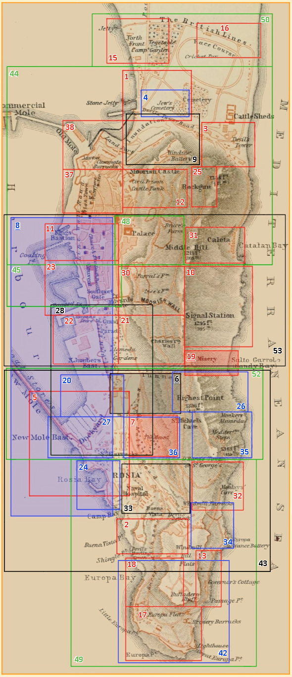
Map by Wagner & Debes (Leipzig: 1908).
Links to Other Websites
Note: The webpages will open in new windows.
Click on the link to go to that page of the website. Click on the icon to go to the website's home page.
Ordnance Survey maps of Gibraltar from 1900 to the 1950s. These are medium resolution images. Note that such images are property of the Garrison Library and may be reproduced only with permission.

Catalogue entries for 37 maps of Gibraltar. Includes some ESRI shapefiles. Use the map viewer to zoom in on a map number icon. Click on the number icon then on the associated map panel on the left.

[ You are at www.majortweedy.com>Molly's Gibraltar> Library Maps ]